Professional Products
-
Additional user on an Annual Copyright LicenceProduct descriptionAdditional user on an Annual Copyright Licence Learn More€153.75 €125.00
-
Aerial Imagery MapProduct description
Aerial Imagery ranging from 25cm to 1m resolution in a custom (site centred) PDF map.
Learn MoreAs low as €40.59 €33.00 -
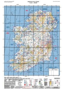
Aero Chart Flat 1:500,000Product descriptionNew 12th edition released February 2022. VFR ICAO aeronautical chart for Ireland (1:500,000) with airports, airfields, airspaces, restricted and hazardous zones as well as air safety information. Published by the IAA. Aero Chart Flat Laminated 1:500,000. Learn More€29.99 €26.42
-
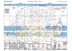
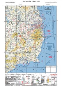
Aero Chart Flat East/west 1:250,000Product descriptionNew 9th edition released February 2022. VFR ICAO aeronautical chart for Ireland (1:250,000) with airports, airfields, airspaces, restricted and hazardous zones as well as air safety information. Published by the IAA. Aero Chart Laminated 1:250,000. Learn More€29.99 €26.42
-
Aero Chart Flat North/South 1:250,000Product descriptionNew 9th edition released February 2022. VFR ICAO aeronautical chart for Ireland (1:250,000) with airports, airfields, airspaces, restricted and hazardous zones as well as air safety information. Published by the IAA. Aero Chart Laminated 1:250,000. Learn More€29.99 €26.42
-
 Out of stockAero Chart Folded 1:500,000Product descriptionNew 12th edition released February 2022. VFR ICAO aeronautical chart for Ireland (1:500,000) with airports, airfields, airspaces, restricted and hazardous zones as well as air safety information. Published by the IAA. Folded and laminated chart. Learn More€29.99 €26.42
 -
Aero Chart Folded East/West 1:250,000Product descriptionNew 0th edition released February 2022. VFR ICAO aeronautical chart for Ireland (1:250,000) with airports, airfields, airspaces, restricted and hazardous zones as well as air safety information. Published by the IAA. Aero Chart Laminated 1:250,000. Learn More€29.99 €26.42
-
Aero Chart Folded North/South 1:250,000Product descriptionNew 9th edition released February 2022. VFR ICAO aeronautical chart for Ireland (1:250,000) with airports, airfields, airspaces, restricted and hazardous zones as well as air safety information. Published by the IAA. Aero Chart Laminated 1:250,000. Learn More€29.99 €26.42
-
Digital Landscape ModelProduct description
Digital vector extract of Large Scale Prime 2 mapping of your area of interest that is defined by you and output in DWG format in ITM
Learn MoreFrom €184.50 €150.00 -
Discovery Map PDF ExcerptProduct description
The Discovery Series Extracts are a site centered plot of your area of interest. They are available in a range of paper sizes from A4 up to A0 and can be delivered to you electronically as a PDF file or printed and supplied by post. It is an ideal reference for location-focused business use or as a wall-mounted reference.Please note that this product is not suitable for navigation purposes and does not have gridlines.
Learn MoreAs low as €54.12 €44.00 -
Height Data ExtractProduct descriptionVAT Standard Learn MoreFrom €34.44 €28.00
-
Historic MapProduct description
Custom (site-centred) PDF map based upon our high quality historic 6" and 25" mapping.
Learn MoreAs low as €49.20 €40.00 -
Land Registry Compliant MapProduct description
Tailte Éireann Registration Division (formerly Land Registry) accepts Land Registry maps, with Irish Transverse Mercator (ITM) co-ordinates shown on the upper right corner and the lower left corner
Learn MoreAs low as €30.75 €25.00 -
PLACE MapProduct description
Printable PLACE Maps are suitable for a broad spectrum of Planning, Legal, Agricultural, Construction, and Engineering applications. Based on our Largescale Prime DLM (Digital Landscape Model), providing national topographic coverage in ITM, they are optimised for printing and are available in black/white and grey, in a range of standard paper sizes from A4 to A0, Landscape or Portrait orientation, to a scaled output of either 1:1,000,1:2,500 or 1:5000 and can be delivered to you electronically as a PDF file (A4 & A3 size only) or printed by Tailte Éireann and supplied by post (A2-A0 size only)
Learn MoreAs low as €54.12 €44.00 -
Planning PackProduct description
Tailte Éireann Large Scale Mapping is required by your Local Authority when applying for planning permission. A Planning Pack consists of one large scale site map (A4 or A3 extent) selected either as a printable PDF or an Autocad DWG and one copy of a site location map (6 inch record place map).
Learn MoreAs low as €59.66 €48.50