Land and Property Maps & Data
-
Digital Landscape ModelProduct description
Digital vector extract of Large Scale Prime 2 mapping of your area of interest that is defined by you and output in DWG format in ITM
Learn MoreFrom €184.50 €150.00 -
Land Registry Compliant MapProduct description
Tailte Éireann Registration Division (formerly Land Registry) accepts Land Registry maps, with Irish Transverse Mercator (ITM) co-ordinates shown on the upper right corner and the lower left corner
Learn MoreAs low as €30.75 €25.00 -
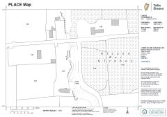
PLACE MapProduct description
Printable PLACE Maps are suitable for a broad spectrum of Planning, Legal, Agricultural, Construction, and Engineering applications. Based on our Largescale Prime DLM (Digital Landscape Model), providing national topographic coverage in ITM, they are optimised for printing and are available in black/white and grey, in a range of standard paper sizes from A4 to A0, Landscape or Portrait orientation, to a scaled output of either 1:1,000,1:2,500 or 1:5000 and can be delivered to you electronically as a PDF file (A4 & A3 size only) or printed by Tailte Éireann and supplied by post (A2-A0 size only)
Learn MoreAs low as €54.12 €44.00 -
Planning PackProduct description
Tailte Éireann Large Scale Mapping is required by your Local Authority when applying for planning permission. A Planning Pack consists of one large scale site map (A4 or A3 extent) selected either as a printable PDF or an Autocad DWG and one copy of a site location map (6 inch record place map).
Learn MoreAs low as €59.66 €48.50


